Sunday, October 30, 2022

Almost Heaven: Road Trip Through the Appalachian Region of Virginia and West Virginia

October 22, 2022

Who would think what happened on earth 270 million years ago would influence our cross-country road trip from Virginia to California? In fact, the earth, the land, the wildlife, the birds, the trees, and the limestone under the ground all played an essential part in our adventures from the East to West Coast.

A billion years ago, the earth’s land formed one supercontinent. The crust of the supercontinent began to thin and pull apart 750 million years ago. A basin formed and filled with seawater and marine sediment. The sea retreated, returned, retreated, returned, and retreated again, leaving behind millions of years of limestone-rich deposits. The continents broke apart 540 million years ago.

Trees, green leaves, wooden foot bridge spanning the pond.

We hiked the Forest Exploration Trail to the Loop Forest Trail at Pocahontas State Park in Chesterfield County, Virginia.

Weather eroded the small, soft sediment and left behind larger and harder pebbles and rocks. The continents began to move toward each other again 470 million years ago. The eastern continent pushed the rocks westward, collided with another continent, and forced the land mass upward, piling up the rocks to form the Appalachian Mountains 270 million years ago.

The Appalachian Mountains were once as big and rugged as the Rocky Mountains. Hundreds of millions of years of erosion have softened the peaks now covered in forests and home to white-tailed deer, moose, black bears, bobcats, the Eastern coyote, beavers, raccoons, American porcupines, fishers, river otters, and snowshoe hares.

White mushroom in a bed of brown leaves.

Amanita cokeri, this large, poisonous mushroom, grows in the woodlands of Virginia.

Smaller, softer sediment washed eastward, forming Piedmont, or foothills, Virginia’s fertile farmland where horses and cows graze from Charlottesville to Richmond and Fairfax to Roanoke.

The earth told Virginia's first people—the Powhatan, the Monacan, the Occaneechi, the Tutelo,  the Sapony, the Cherokee, the Mannahoac—how and where to travel—around its mountains, over its ridges, and across its rivers. We thank the native people of this land on whose trails we travel.

Ultimately, the landscape created ideal conditions and flavored the water just right to make the best bourbon anywhere. It carved out limestone caves far under the ground that we explore today all while sheltering animals long enough for them to evolve into unique creatures (cave fish and amphibians). It grew the trees where birds flit and flutter—trees that made the wood we cut and turn to make baseball bats and bourbon barrels.

Highly pressurized layers of earth created coal, copper, gold, silver, and petroleum deep underground. Opportunists flocked to the land to get rich. Communities and economies rose and fell or sometimes disappeared altogether, leaving behind a barren and defiled land that even the factories didn't want anymore.

Fall foliage hillside and pasture with a fenced road through it.

Beginning to see the rise of the Valley and Ridge Province of the Appalachian Mountains, just west of the Blue Ridge.

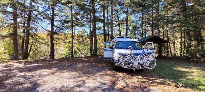
In this article, we interrupt stories about our Fall 2021 trip to write about our latest trip: Fall 2022 Cross Country or #Fall22XCountry. We traveled from Midlothian, Virginia, to Palm Springs, California, in our 1996, 19-foot Dodge Pleasure Way RV van, recently named Sweet Van-Ella Magnolia, or Ella for short.

We retrieved Ella from Genito Mini Storage in Midlothian, where she had been in storage since the end of our 2021 New England Fall Foliage trip.

Passenger seat view of road ahead and fall foliage trees on both sides of road.

Almost heaven, indeed. I was reminded of a childhood memory, riding in the back of Uncle Ken's pickup on a gravel road to the dump in Brooklin, Maine, with the garbage and my cousin at my side, our hair blowing in the breeze, belting out, “Take me home...Country road...To the place...I belong!”

We drove through the Piedmont region on I-64 to Charlottesville, Virginia, made a pitstop, then drove another two hours on winding country roads through Churchville and Monterey through the mountains of western Virginia. We passed farms and pastures full of horses, Black Angus cattle, and flocks of sheep. When Ella reached the top of a pass, the view opened up to a beautiful vista of soft mountain peaks covered in rusty shades of gold, orange, red, and green.

Camper van parked in a campsite with stone fireplace.

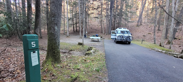
Campsite #5 at Seneca State Forest, also known as Seven Mile Campground.

We turned onto Highway 220 in Monterrey and soon crossed into West Virginia. Then on Route 92, Google wanted us to hang a left onto a country road to cross over a ridge to reach route 28, which would take us to the campground. That little road looked too country for us and our van, and we continued on 92 and met 28 a few more miles down the road. Another reminder that Google's directions are suggestions, and we should preview them before starting out for the day. 

Map of trail from Midlothian to Seneca State Forest.

Our route from Midlothian, Virginia, to Seven Mile Campground in the Seneca State Forest, West Virginia.

We had downloaded offline maps, having been warned that this is a radio-free zone with no Internet or cell phone reception. According to Wikipedia, “The National Radio Quiet Zone (NRQZ) is a large area of land in the United States designated as a radio quiet zone, in which radio transmissions are heavily restricted by law to facilitate scientific research and the gathering of military intelligence.”

Man in front of stone fireplace with shopped fire wood piled in front of him.

Our stay at Seneca Forest Campground was the best camping experience on the whole trip.

Our first two nights were at Seneca State Forest Campground, also known as Seven Mile Campground. We arrived at site #5, situated next to a leaf-covered slope of hardwood trees. This small campground with only 10 sites is by reservation only. The site next to us was occupied, as was one further down the campground road. Other than a few cars on the highway and the dried leaves rustling in the breeze or scampering squirrels, it was quiet.

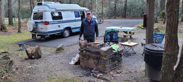
We made a fire in the stone firepit (the $6 camp wood not terribly dry) and ate a dinner of BBQ pork and pasta salad.  Roger was reminded to always maintain some dry kindling and newspapers for starting fires with wet campground wood.  He had to resort to his old Boy Scout trick for starting a fire using a small wad of duct tape sprayed with WD40 and placed in a paper bag.
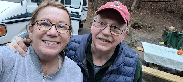
Woman with hair pulled back and glasses and man with red ballcap and glasses.

First-night selfie! 

Nighttime temperatures were chilly. Ella’s heater worked at first but then stopped reigniting during the night. Only the fan blew. Luckily, our sleeping bags were rated for cold weather. We woke to chilling temps and donned knit caps for coffee hour.

October 23, 2022

After a leisurely morning of coffee, reading, writing, and breakfast, we made our way over the mountain and through the woods on the narrow, winding Laurel Run Road to Clover Lick Depot. I didn’t think it was wide enough for two cars to pass. Roger said there was plenty of room and proved it when a pickup met us coming the other way.

At the other end of Laurel Run Road, a narrow, wooden bridge crossed the Greenbrier River, and Clover Lick Depot, one of the designated trailheads of the Greenbrier River Trail, was on the right.

Bike path passing between bushes and former train depot building.

The Clover Lick Depot is 10 miles northeast of Marlinton, West Virginia.

We geared up and were on our way. The trail, a former railbed between Caldwell to the south and Cass to the north, is 80 miles long. We rode out and back about 14 miles roundtrip. We met two couples traveling together on rented e-bikes. They used a shuttle service from Marlinton, where they were staying in a hotel, to drop them off at Cass. They rode one-way back to Marlinton.

Man standing with bicycle and bike trail behind him.

Autumn leaves often covered the trail.

Assisted bikes were not necessary for this trail, but they make access to beautiful places like this possible for people who might have difficulty pedaling a regular bicycle. The trail was mostly level and dry (just a few muddy spots) with double, packed paths. Mountain bikes were not needed. We rode street bikes.

River with trees and hills on either side.

The trail follows the scenic Greenbrier River adorned in its coppery reflections of late October foliage.

The most unique aspect of the trail was Sharp’s Tunnel, a deceptively long and dark tunnel at around mile marker 65. The tunnel’s center was pitch black, and we had no depth perception. We rode through the tunnel on blind faith that the path below us was clear and solid. On our return trip, we met people coming from the other direction. We would have run into them if they hadn’t had a light.

Wooden foot bridge leading to a dark tunnel entrance.

Sharp’s Tunnel was straight out of a Roadrunner cartoon.

The trail also featured beautiful white stone and cement mile markers every five miles. The Greenbrier River Trail website has a downloadable map that comes in handy because there is no phone service in this radio-free zone. The map displays the mile markers, campsites, rest stops, and special features along the way.

Forest trees with a campsite shelter in the distance.

Some people take several days to ride and camp along the entire 80-mile trail.

We rested, ate a picnic lunch at the rest stop beyond the tunnel, and then headed back. Total trail time was about 3.5 hours at a comfortable pace with plenty of time for photos. The temperature on this sunny day warmed up after a chilly morning, and we rode in shorts and t-shirts. Along the way, the trail has porta-potties and old-fashioned water pumps for refilling water bottles. (FYI - No bathroom at Clover Lick Depot.)

We returned to Seneca State Forest / Seven Mile Campground at around 4 pm. Roger marinated boneless, skinless chicken thighs with his special Rusty Chicken recipe and cooked it on the open fire. With our bellies full of chicken, deli potato salad, and a few happy hour cocktails, we slept well through the night.

During the morning hours in the Seneca Forest, my Merlin bird Sound ID app identified a blue jay, a white-breasted nuthatch, a golden-crowned kinglet, a house sparrow, a Carolina wren, a northern flicker, a northern titmouse, and a red-breasted nuthatch. I heard an owl in the evening hours but wasn't quick enough to ID it with the app.

*Subscribe to our blog, and we’ll send you a copy of Roger’s Rusty Chicken Recipe.*

Man sitting in camp chair in front of stone fireplace with chicken grilling on top.

Roger in his glory—cooking over an open wood fire.

Monday, October 24, 2022

We reluctantly left the Seneca Forest. One of our favorite campgrounds anywhere. We drove southwest toward New River Gorge with a stop at the public library in Marlinton to request our Electronic/Online Delivery Absentee Ballots from the Alaska Division of Elections.

The McClintic Public Library had a set of computers for public use and a friendly and helpful librarian. It also had a pay-what-you-want used book sale in the corner of the library, and I paid one dollar for a copy of Braiding Sweetgrass by Robin Wall Kimmerer.

Marlinton, the Pocahontas County seat, also has one of the more popular trailheads to The Greenbrier River Trail. Marlinton is full of railroad and logging history. It’s a great small-town destination.

We drove US 219 South, also known as the Seneca Trail, through the mountains of Pocahontas County and along the James River and Kanawha Turnpike Ha! Turnpike! The “turnpike” must have been a joke the locals pull on tourists. The narrow, twisting, turning road almost made me car sick. I can’t praise Roger’s driving skills and patience enough.

"Finally, we entered hill country, climbing higher and deeper into the Appalachian Mountains, stopping from time to time to let the Oldsmobile catch its breath on the steep, twisting roads. It was November. The leaves had turned brown and were falling from the trees, and a cold mist shrouded the hillsides. There were streams and creeks everywhere, instead of the irrigation ditches you saw out west, and the air felt different. It was very still, heavier and thicker, and somehow darker. For some reason, it made us all grow quiet." — The Glass Castle by Jeannette Walls

We arrived at Chestnut Creek Campground in full sunshine. This primitive-style campground was near the national park visitor center. A young family owned it, and their flock of chickens roamed freely. We selected site #30 because it was closest to the bathhouse.

Leaf-covered campsite, picnic table, and RV van.

Site #30 at the rustic Chestnut Creek Campground.

Although primitive, the campground had flush toilets and showers. Designed for tent campers, this campground had a relaxed and quirky style. The gravel road to the campground was bumpy, so be prepared and don’t try to drive it with a big RV. The park advertises wilderness-style camping—a place you can pull in for the night and get a shower if you have a small footprint.

A river in the distance at the bottom of a deep gorge.

Despite its name, the New River is not new. The river carved the gorge over the previous three million to 350 million years.

Other campers were rock climbers—three guys from Louisville tent camping and a woman from New York traveling in a newer Dodge 3500. She was in the process of converting it and gave Roger a tour. Offering a tour of your van home is an unofficial van travel courtesy. RV travelers, in general, like to share ideas for power, batteries, storage, solar, heat, water, and refrigeration.

The weather was warm that day, and tiny gnats swarmed the campsite. We called it an early night and retreated to bed.

Tuesday, October 25, 2022

We got the van road ready early the next morning and drove to the trailhead of the Endless Wall Trail. The New River, which is actually older than the Appalachian Mountains, cut through the Appalachian Plateau and exposed rocks more than 330 million years old.


Rocks protude along the length of the gorge far into the distance.

A scenic overlook on the Endless Wall Trail.


After the Visitor Center, we drove the winding, one-way Fayette Station Road Audio Tour to the bottom of the gorge. The audio is available online, syncs with driving time, and describes the area’s coal mining, logging, and railroad history. Fayette Station Road was the main travel route for nearly 100 years.

RV van parked under the New River Bridge.

Our Sweet Van-Ella at the bottom of the New River Gorge near Fayette Station Rapid.

We explored the nearby town of Fayetteville with kaffeetrinken at the Cathedral Cafe, which specializes in local and seasonal ingredients and features Equal Exchange Fairly Traded coffee, tea, chocolate, and food products. The cafe is located inside a former church and is home to a self-serve used book exchange. Books are free or by donation. Proceeds benefit the local animal shelter, women’s shelter, and food pantry.

Two cups of coffee and cake on a cafe table.

Cappuccino and Ultimate Carrot Cake at the Cathedral Cafe in Fayetteville.


A few steps away and across the street, we bought souvenirs at Wisteria’s Gifts before hopping in the van for a short ride for pizza and beer at Pies & Pints. I thought I would find plenty of "Almost Heaven" t-shirts to go with my "Take It Easy" t-shirt from Winslow, Arizona, but I didn't find any.

We returned to the campground and were woken early by roosters crowing at the dawn. Time to hit the road and on to our next adventure—bourbon, baseball, and bats.

Resources:

The Piedmont Region of Virginia (Retrieved, 12/22/2022)

West Virginia Economical and Geological Survey (Retrieved, 12/22/2022)

Birth of the Mountains (Retrieved, 12/22/2022)


National Park Service, various brochures & websites


Further Reading:

Roadside Geology of West Virginia by Joseph Lebold and Christopher Wilkinson

The Glass Castle by Jeannette Walls


Edited 12/28/2022

© copyright 2022. Patricia E. Harding. All rights reserved.


Wednesday, October 5, 2022

The Great North Woods of Western Maine

New England Fall Foliage 2021

October 1 - 5


My husband and I went on a New England fall foliage road trip in 2021. COVID, still a serious threat, was slowly working its way into the rearview mirror. The United States had withdrawn from Afghanistan, and Hurricane Ida was wreaking havoc along the East Coast. A good time to escape to the Great North Woods.

The view of Mt. Katahdin from I-95 Scenic Overlook at Mile 252.

Most travelers to Maine enter via I-95 across the Piscataqua River Bridge to Kittery, then travel coastal Route 1 north. Some make it as far north as Portland. A few to Camden. Many skip all that and head straight to Acadia National Park. A few lucky ones veer westward and discover the beauty and serenity of the Maine woods, mountains, freshwater lakes and ponds.

Our tour through Maine took what some would call a backward route. We entered from New Hampshire via Route 2. We wanted to stay ahead of potentially cold and freezing weather in the mountains, so we planned interior Maine for the first part of the tour and coastal Maine as our exit route because the ocean tends to moderate temperatures along the coast.

The road ahead with Maine sign.

It feels good to be home again.


I am from Maine, and we had many friends and family to visit along the way—including two friends from Juneau who also happened to be there. We set November 1 as our target departure date to avoid the possibility of running into snow. I have experienced Halloween snowstorms in the past.

This section of our trip was the most remote. We stocked plenty of fuel, food, and drinking water. There might be a day when that Luggable Loo would come in handy. (See the Vermont article about how we prepared for this trip.) Bethel was the perfect stop for reprovisioning. We found a parking space across from the Bethel Foodliner on Main Street. That was too easy.

Rolling hills of Western Maine.


There’s something about coming home to Maine that recharges my heart with positive energy and feelings of nostalgia. It doesn’t matter where in Maine I am; I get a this-is-where-I’m-from feeling. I also looked forward to sharing western Maine and Baxter State Park with my West Coast husband.

Roger grew up near Sequoia and Yosemite National Park—one of the first national parks in the country, designated in 1890. Fortunately, naturalists recognized the need to protect the land from private development and set unique places aside “for the benefit and enjoyment of the people.”

Western Maine views are full of farmland, ponds, rivers, and mountains.


Roger says the East Coast national parks are cute as they don’t compare in size to the expansive parks of the West.

During a drive through Shenandoah National Park a few years prior, we learned that city folk in New York, Boston, and Philadelphia also wanted to escape to the wilderness. Hence, the Park Service designated national parks in the East within a driving distance of major population centers.

The North Woods offer expansive views of mountains and lakes.


We have a fondness for state and national parks. Everyone can enjoy public lands in their natural state. Our current home in Southeast Alaska is part of the 17-million-acre Tongass National Forest. Public lands are accessible anywhere, anytime, without many restrictions due to special permission or permits. Contrast that to Maine, where 94% of Maine’s forests are privately owned. Fortunately, landowners in Maine provide public access to more than 10 million acres, often by permission or permit. (www.maine.gov, retrieved 9/22/2022)

A woodpecker visits us on the trail.

Maine also has designated public lands. The Maine Department of Agriculture, Conservation and Forestry, Bureau of Parks and Lands has a brochure detailing state parks, public lands, and state historic sites. It’s a great resource when planning an overland trip through Maine.

Unfortunately, my euphoric Maine high bubble burst after grocery shopping in Bethel when Roger tried to restart the van. Barely a click. Our first thought was a dead battery.

Yes, we were frustrated, but we were also grateful in hindsight. When you live on the road, you must accept a dead battery, a flat tire—a broken fuel pump! (see our Carlsbad, N.M., article)—can and will happen on any given day. What better place to have a dead battery than on Main Street in the middle of town and in front of a hardware store?

A bouquet of lichen.


 After unsuccessful attempts to fix the problem, Roger went to Brooks Bros. Hardware (fortuitously located next to us) and asked for help. A man who worked there came out and assessed the situation.

“I can see your problem right they-ah,” the man said in a thick Maine accent. He noticed that one of the terminal wires had come loose from the old clamp-style battery terminal, and after stripping and reattaching the wire, the van started with a quick jump from his truck. He adamantly refused any form of payment. Come to find out, he used to manage the local auto parts store for many years and now worked at the hardware store as a part-time retirement job, “to support my wife’s gardening habit,” he said.

Steak dinner cooked on the open fire.

We were on our way, feeling elated. We could have broken down at many remote locations in the previous several days. I suspect the rough ride on Route 16 north in New Hampshire or on Route 2 west jiggled the battery wires. I recall Roger asking if I wanted to stop for photos along the way. No, let’s keep going. This was one of those situations when I was glad we didn’t stop to smell the roses.

Mt. Blue State Park Campground

Our next planned stop was originally Sugarloaf Golf Course and boondocking at the West Mountain golf course parking lot D or the Sugarloaf Outdoor Center. Information found online described both places as options, but both seemed iffy. I have learned from experience that I feel more comfortable with firmer plans.

Campsite with picnic table and firepit. Man standing at picnic table.

Starting to feel the cool fall weather at Mt. Blue State Park Campground.


Boondocking at Sugarloaf would have been adventurous and van-lifey, but we changed our minds and continued to Mt. Blue State Park Campground in Weld, a natural stop for RVers traveling from The White Mountains in New Hampshire to Acadia National Park in Maine. Of all the places on this trip, Mt. Blue is where I would have spent more time.

Map

Our route through Western Maine.


Mt. Blue State Park and the surrounding Tumbledown Public Lands deserve to be a destination by itself. The state park encompasses 8,000 square miles. The adjoining public lands add 22,000 acres. Ice sheets sculpted this land between 18,000 and 14,000 years ago, leaving behind mountains, valleys, rocks, and lakes. Seven major hiking and more accessible nature trails include the popular and challenging Tumbledown Loop Trail at 3,068 feet.

Roger fried burritos for dinner.


The campground is located on the opposite shore of Webb Lake from the state park, with access via West Side Road. (If you go, pay attention. We missed the turn the first time.) We arrived during the first-come, first-serve off-season and had no problem finding a site. A group of campers near us were traveling together and having a good time. The rest of the campground was quiet, and the chilly evening air called for a fire.

Lakewood Golf Course

(NOTE: On some days, we put our phones away and take a break from photos. Neither Roger nor I took pictures at the golf course. We must have been tired! Enjoy these photos from Brighton Farm.)

Marigolds.We left Mt. Blue the following day and headed toward Skowhegan, where we had a tee time at Lakewood Golf Course in Madison. The area had experienced heavy rains before our arrival, and the course was soggy. Course challenges included “natural pollinator habitats,” with a penalty for searching for your ball in this area of tall grass and wildflowers. Was this the golf course’s clever way of warning against bee stings?

Modest homes with backyard gardens, apple trees, and chicken coops lined the fairway. One house had a “No Trespassing” sign and a rack of golf balls for sale in the backyard.

Pumpkin and butternut squash.
A unique aspect of this course was the par-six on hole 12. I had just about given up by then. I was cold, tired, hungry, and had wet feet. After nine strokes, I picked up my ball, still a reasonable distance from the pin. Roger got it in on nine. Most of the other holes were par-four, with four par-threes and two par-fives.

On top of the poor conditions of the golf course, we received disturbing news while still on the course. Text messages from friends and family in Juneau alerted us to a micro-burst wind storm that blew through our neighborhood and felled a large tree on our property, missing our house by inches. A branch hit the side of the deck and broke a railing, and the tree scrubbed the side of the house, pulling off the utility connections.

Neatly stacked wood pile.
This news would have been shocking to us had not the same thing happened the year before! Yes, we had just finished repairs from a fallen tree in 2020 before we left Juneau for this trip. All we could think was, here we go again.

Roger has the best logistical skills of anyone I know, and in a short time, he made the necessary calls to get the immediate damage cleaned up and the utilities repaired. With the help of family and friends, we could continue our trip and deal with the rest when we returned home in mid-November, knowing that our summer fish in the freezer was safe.

Brighton Farm

Friends invited us to boondock on their farm in Brighton that night. What a sight for sore eyes. They built their home and developed the organic farm themselves over many years. The details in the house and garden revealed their creativity. The farm’s groovy vibe relieved the stress of worrying about our home in Juneau.

Camper van parked in driveway with house in background.

"The Road to a Friend's House is Never Long"


We sat outside and visited amidst baskets of recently harvested vegetables and pots of overflowing marigolds and climbing mandevilla. We ate a harvest dinner and retired to the van with bellies full and minds stimulated from reminiscing.

Peace sign hanging on cedar-sided wall.

Brighton Farm provided a peaceful respite from the road.


I arose early to join my friend outside for sunrise coffee. He said he has sunrise coffee on the stone patio every morning. “Can you believe we haven’t had a frost yet? The first week of October, and we haven’t had a frost in Maine. Unbelievable.” Tomatoes were still ripening on the vine, and he hoped the peaches on his tree would benefit from the late frost. Peaches are an unconventional fruit to grow in Maine, but as the climate changes, so do the gardening zones.

Maine peaches ripening on the tree.

I appreciate imaginative and intuitive people who prioritize daily rituals such as sunrise coffee—a peaceful and meditative way to start the day. Our time with Bob and Arlene was just what we needed at this point on our journey. Thank you! What an inspiration.

You can find the Brighton Farm Group on Facebook. You can also listen to Bob Lovelace’s music at either Apple Music  or on Spotify .

[UPDATE: Readers, a few days after publishing this article and one year after our visit, Bob & Arlene Lovelace lost their beautiful house in a fire. Thankfully, they were not physically harmed, but their home is a total loss. The best way for people to help is a donation to Fire relief GoFundMe, set up by family members. If you're able to, please make a donation. Thank you!]

Later that morning, we met another group of friends at Coburn Park in Skowhegan for more coffee, doughnuts, and visiting. 
 Relationships are often situational and fade away as time passes. I’m thankful these friendships have lasted, some going on 20+ years!

Grave marker.

 A short detour in Madison to remember a friend.


Baxter State Park

We had a long drive ahead of us, north on I-95 via Newport, Bangor, Orono, Old Town, Howland, Medway, Sherman, Staceyville, and Patten. A three-hour, 168-mile drive to Matagamon Gate, the northern entrance to Baxter State Park.

Couple posing in front of mountain and pond scenery.

The best photo we would get of Mt. Katahdin.


Since we were not climbing Mt. Katahdin, we avoided the crowds of Appalachian Trail thru-hikers and leaf peepers and chose to stay at Trout Brook Farm Campground, site #27. We booked three nights, and although the Internet is full of warnings about RVs and vehicle requirements (“No vehicle over 9’ high, 7’ wide, or 22’ long”) entering the park, we had no problem. While our van was within their size requirements, we didn’t know how carefully they were going to measure. Our bike rack and bikes make the van a little longer than 20 feet. 

Sun shining through the trees to a campsite. Man sitting in front of fire pit.

Site #27 at Trout Brook Farm Campground at Baxter State Park.


Don’t get me wrong. Heed the warnings. This park belongs to Maine, and its minders are adamant about keeping it primitive. Besides, you wouldn’t want to drive an oversized vehicle or RV on the park’s narrow gravel Tote Road. From the gate to the campground was far enough for us.

Brown trail sign with white lettering, nailed to a tree.

We accessed the trailhead across the street from the campground entrance.


Baxter State Park has many rules you may not find at other campgrounds. The park provides a pdf copy of the regulations at BaxterStatePark.org. The Baxter State Park Facebook page is also helpful but can be confusing when commenters contradict each other. Call the park headquarters directly when in doubt and ask a park ranger.

Woman in blue shirt posing with fall foliage vista in view.

Beautiful view from Trout Brook Mountain.


The park was peaceful, and we saw the most beautiful starry sky. During the day, we hiked Trout Mountain. We looked for Katahdin, but other peaks were in the way. Nevertheless, the overlooks opened up to views of the richest fall colors as far as the eye could see.

Cobscook Bay State Park Campground

The next leg of the journey took us from the mountains to the sea. To get there, we had another long day of driving on two-lane highways, backroads, and through small towns where the folks didn’t always act like the welcome committee. For example, when we pulled up to the Irving gas pump at Smith’s General Store in Springfield, a man in a pickup cut us off. He glared at us with an ugly eye and responded with an insult when Roger asked how to use this particular pump.

Camper van parked at a rest area on the side of the road.

Rest stop between Baxter and Cobscook.


We live in Juneau, a tourist town, so we know what it’s like to have tourists crowding the stores, streets, and sidewalks. On this day, we got to feel the disdain of locals firsthand. Nothing we couldn’t shake off, but it reminded us that not everyone is as enamored with van life as we are.

Foliage reflection in a quiet stream.


Cobscook Bay State Park Campground is situated along the coast with campsites high above the water overlooking Cobscook Bay. We arrived during the off-season, first-come, first-serve status. Campers had already claimed the best waterfront sites when we got there, but we found one with a peek-a-boo view through the trees. The trees couldn’t filter out the smell of the clam flats in the morning. Ah! That fresh Maine air!

The road ahead lined with colorful tree foliage.

The road we travelled by.


We traveled down the coast of Maine during the next leg of our journey. That part we will share in the next installment of this blog. Stay tuned!

Sunrise coffee at Cobscook Bay.


Into My Own
By Robert Frost

One of my wishes is that those dark trees,
So old and firm they scarcely show the breeze,
Were not, as ‘twere, the merest mask of gloom,
But stretched away unto the edge of doom.

I would not be withheld but that some day
Into their vastness I should steal away,
Fearless of ever finding open land,
Or highway where the slow wheel pours the sand.

I do not see why I should e’er turn back,
Or those should not set forth upon my track
To overtake me, who should miss me here
And long to know if still I held them dear.

They would not find me changed from him they knew—
Only more sure of all I thought was true.
From The Collected Poems of Robert Frost, Henry Holt and Company, Inc., 1930. Originally published in A Boy’s Will in 1913 by David Nutt, London.

© copyright 2022. Patricia E. Harding. All rights reserved.